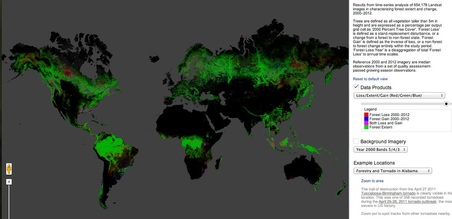
 Tree cover (green), loss (red) and gain (blue), per Hansen et al. (2013).
 “A total of 20 terapixels of data were processed using one million CPU-core hours on 10,000 computers….”
A brief summary of the computational requirements for what I consider to be the most groundbreaking scientific paper that I read in 2013. The result of this number crunching is the first truly comparable and global map of forest cover, loss, and gain. All at the staggering scale of only 30 m. The paper, published by Hansen et al. in Science in November, processed satellite images of the earth’s surface using Google’s Earth Engine cloud platform between 2000 and 2012. The data will shortly be made publicly available, but for the time being they can be viewed on an absolutely captivating and easy-to-use website. When you open a browser to look at this map, be prepared to spend some time exploring.
A brief summary of the computational requirements for what I consider to be the most groundbreaking scientific paper that I read in 2013. The result of this number crunching is the first truly comparable and global map of forest cover, loss, and gain. All at the staggering scale of only 30 m. The paper, published by Hansen et al. in Science in November, processed satellite images of the earth’s surface using Google’s Earth Engine cloud platform between 2000 and 2012. The data will shortly be made publicly available, but for the time being they can be viewed on an absolutely captivating and easy-to-use website. When you open a browser to look at this map, be prepared to spend some time exploring.
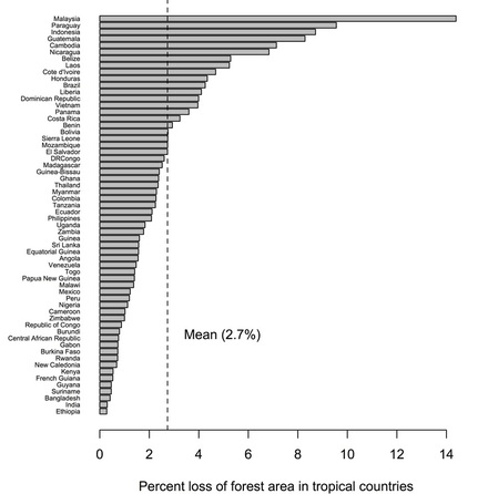 Loss of tree cover in tropical countries, per Hansen et al. (2013).
 Below, I have plotted the loss of tree cover in tropical countries. For me, the noticeable features are 1) the rates of deforestation in Brazil (there as been a ~50% reduction in ~7 years, the direct result of effective governance) and 2) the striking need for improved conservation in SE Asia (probably an underestimate, as the results do not accurately account for expansion of oil palm monocultures).
In the past, different entities with different underlying data, different analysis and different motivations have produced different maps of deforestation at different spatial scales. Each map was….different. This is the first time we have ever had a global map applied with the same methodology. The results are not without their problems; however, I have every expectation that the quality will improve with time. That this map is online for anyone from governments to grandmas to use is going to fundamentally transform our capacity for effective conservation.
Citation: M.C. Hansen et al. 2013. High-resolution maps of 21st-century forest cover change. Science 342: 850-853.
 RSS Feed
